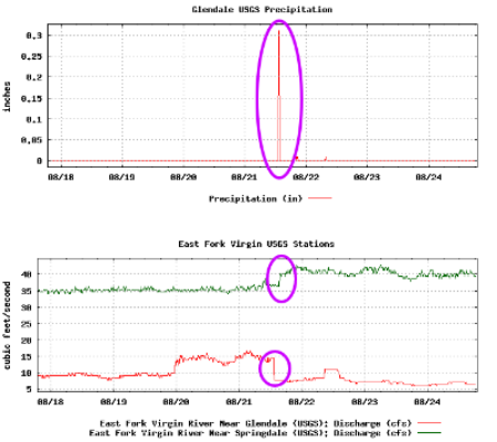
The above two near real-time graphs show precipitation at the EF Sevier River nr Glendale station and a combined graph of the flows at EF Sevier River nr Glendale and EF Sevier River nr Springdale. Contrasting the two graphs will sometimes show discontinuities in the flow graphs of the two stations during heavy prectipitation events. This may cause the stream channel where the USGS gaging sites are located to change its depth and profile. If this occurs the conversion between measured gage height and discharge (flow) may not be accurate until USGS personel have had a chance to revise the rating tables and offsets.
The two graphs below, from August 2017, show a precipitation event which appears to have altered the stream channel in which the gaging stations are located. Note that the flow changes abruptly for both sites at the same time as the rain event which dropped 0.3 inches at the Glendale USGS gaging site.